
By Keith Holmes
When emergencies occur, their impacts can be devastating. Beyond the tragic loss of human life, the hazards left in a disaster’s wake can leave people without food and shelter and cut communities off from the world around them.
With the global impacts of climate change causing a rise in the severity and frequency of extreme weather events, we are seeing more of these emergencies here in Canada. From coast to coast, natural disasters are knocking out power, severing supply chains, and creating risk to public safety.

In the wake of the destruction, it’s important for governments of all sizes to have a plan in place to quickly assess the damage, work with industry and community stakeholders on solutions, and act on the path forward, all within a short amount of time. The faster boots can get on the ground, the sooner people can put their lives back together.
British Columbia’s atmospheric rivers
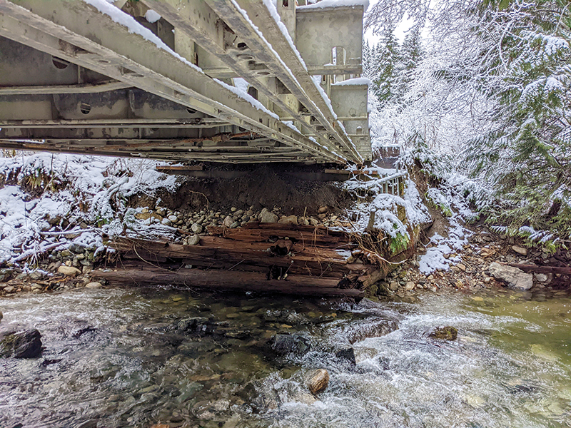
When the atmospheric rivers hit B.C. in November 2021, they left a path of destruction in the southern part of the province. The worst hit communities, within a few hours’ drive north and east of Vancouver, saw rivers overrun their banks, sections of roadways wiped out, farms flooded, and people unable to access nearby urban centers.
A team from WSP Canada was one of several that was put, almost immediately, into action across the province to assess the damage that had been done and figure out how best to create a solution that allowed people and goods to move into the affected areas. The stories they share demonstrate how quickly action was taken, both by government and industry partners, to support people in every community.
 Kevin Henshaw – Lead Engineer, Hydrotechnical
“For me, Jones Creek was perhaps the most exciting because we were on site and involved in making on-the-fly decisions while there was a significant threat of another major highway washout.
Located on Highway 1 near Laidlaw (17 kilometres southwest of Hope), the initial avulsion of the river diverted the flow overland, bypassing the existing highway bridge, and into separate culverts. We were notified of the issues on November 26 and team members Michael Bird and Chris Coles deployed to the site immediately, providing detailed observations that night.
The next day, November 27, we were called into an emergency MoTI meeting because another flow event was taking place, threatening washout of the culverts and Highway 1. Continuous discussion and analysis carried on through that weekend. Two days later, Michael and Chris were back on site reviewing the changing conditions and strategizing options. We completed our analysis and provided recommendations to MoTI for immediate action the next day. On December 1, actions were implemented with construction on site. Chris was back on site to help direct the construction effort to divert creek flows back under the bridge. On December 2, emergency construction was complete and working as intended.
At Jones Creek, we had a real role in providing rapid response on site and, through close collaboration with the MoTI team and on-the-fly analysis, we were able to propose and implement a solution that led to the highway being saved.”
Charles Chataway – Lead Engineer, Bridges
“On November 22, I received the call to conduct inspections on numerous bridges within Service Area 7, which encompasses Silver Skagit, Chilliwack Lake Road, and the Columbia Valley. The B.C. Ministry of Transportation and Infrastructure (MoTI) wanted to conduct a series of rapid structural evaluations, ensuring that every bridge structure in the impacted area had been physically inspected.
“The next day we drove out Highway 7 to the impacted area, as Highway 1 was under water near Sumas Prairie. We travelled as far as we could up Silver Skagit Road until we discovered it was washed out. We performed preliminary road and bridge/culvert/road assessments using the MoTI’s emergency response app on the way. We were able to visit several structures in the area that day to provide a visual assessment of the damage.
“A few weeks later, on December 13, we returned to the Silver-Skagit Road area by helicopter to fly the road past the washout we encountered. We assessed the rest of the bridges and culverts beyond where wheeled travel was limited.
“As a result of what we saw during our evaluation, we developed a high-level program to scope the repairs—which were extensive.”
 Glen Rutherford – Senior Principal Geotechnical Engineer
“Pulling up to this gigantic hole in the highway was quite intimidating. The sense of the enormity of this task became apparent almost immediately, but the site team (including WSP) got to work right away. I was asked to assist with the Falls Creek site (Jackass Summit) on Highway 1 (Trans-Canada Highway) just south of Lytton on November 19.
“The washout totally severed the Highway 1 access south from Lytton towards Hope and to the rest of greater Vancouver. The hole in the road was 25-metres deep and 80-metres wide. The road embankment (and pre-existing culvert) was washed down towards the river, severely impacting the CN Rail track at the bottom of the embankment, in addition to the damage it had done to the highway.
“Our team worked with MoTI to determine geotechnical parameters toward re-establishing the creek channel, identify what kind of earthworks might be possible from a temporary basis, and provide foundation recommendations for the temporary Acrow bridge installed at the site.
“The actions taken by our rapid response team also helped provide the preliminary dataset for a future permanent solution to the crossing.”
Planning for a quick response
What our team learned from the devastation of the atmospheric rivers in B.C. was that the rapid deployment of an established emergency response plan is vital to help reduce the human impacts of disasters. Finding ways to safely access sites, conduct a thorough investigation of the damage, and quickly provide options for temporary and permanent solutions is invaluable in getting transportation routes re-opened. And in doing so, we can ensure that people and goods move in and out of the impacted areas to provide the support that is desperately needed.
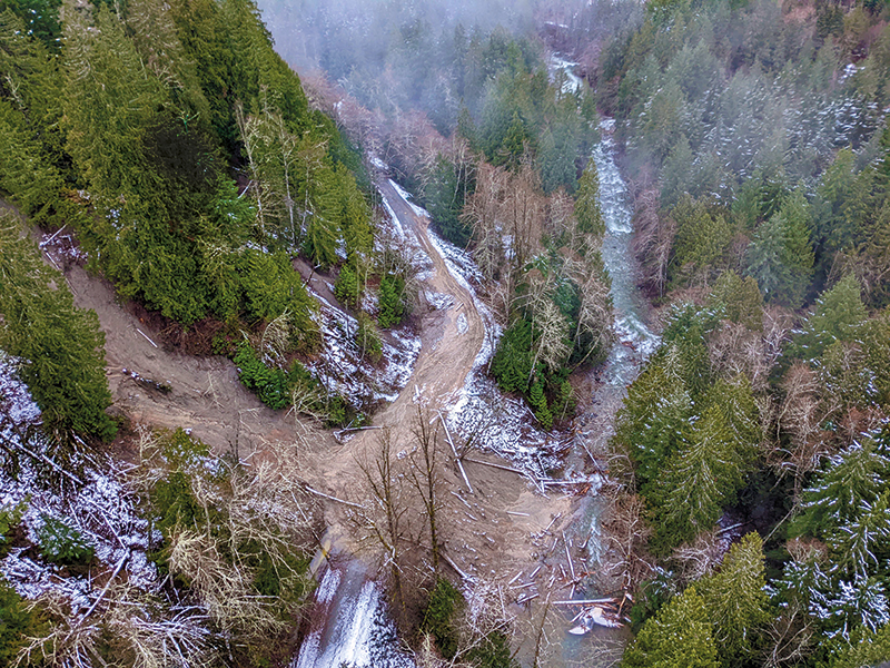
When the atmospheric rivers hit B.C. in November 2021, they left a path of destruction in the southern part of the province that saw rivers overrun their banks, sections of roadways wiped out, farms flooded, and people unable to access nearby urban centers.
[This article originally appeared in the May/June 2023 edition of ReNew Canada]
Keith Holmes is the director, Bridges, BC/Yukon, WSP Canada.
Featured image: When the atmospheric rivers hit B.C. in November 2021, they left a path of destruction in the southern part of the province that saw rivers overrun their banks, sections of roadways wiped out, farms flooded, and people unable to access nearby urban centers. (WSP Canada)